
Smart farming is often described as a network of connected devices gathering information from fields, equipment, weather stations, and irrigation systems. That description is accurate, but it is incomplete. A farm can have dozens of sensors and still lack a clear view of what is happening between those monitoring points. Soil moisture probes may reveal conditions in one part of a field, for example, while crops only a short distance away experience something different.
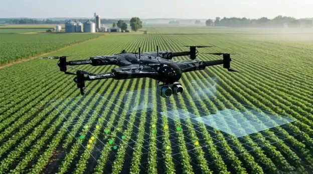
This is where smart farming with drones adds another dimension. Drones can move above a field, capture imagery across wider areas, and reveal patterns that fixed devices may not detect. When this aerial information is combined with IoT sensors, artificial intelligence, GPS, analytics, and farm management software, agricultural teams can build a more complete picture of field conditions.
The important point is that drones do not have to replace ground-based technology. Their value often comes from complementing it. IoT devices can provide continuous readings from specific locations, while drones provide mobile, visual, and spatial information across the broader farm.
Why IoT Sensors Alone Cannot Show the Whole Farm
IoT sensors have become useful tools in precision agriculture because they allow growers to measure conditions that would otherwise require repeated manual checks. A soil moisture sensor can track changes in water levels. A weather station can measure temperature, humidity, rainfall, and wind. Other connected devices can monitor soil conditions, irrigation systems, storage environments, equipment, or greenhouse operations.
These systems provide something traditional field inspections cannot easily offer: regular measurements from the same location over time. That makes them valuable for observing trends and triggering alerts when conditions move beyond selected limits.
Their greatest strength, however, can also be a limitation. Most agricultural sensors monitor particular points rather than every square metre of a field. A reading from one probe may accurately describe the soil around that probe without representing conditions several hundred metres away.
Agricultural fields are rarely uniform. Drainage, soil composition, elevation, plant density, irrigation coverage, shade, pests, and previous land use can all create differences within the same area. A farmer relying only on fixed monitoring points may therefore know conditions at several locations while still missing patterns between them.
Adding more sensors can increase coverage, but installing a dense network across a large property is not always practical. Hardware must be purchased, positioned, powered, connected, maintained, and occasionally replaced. Some areas may also be difficult to reach or may not justify permanent equipment.
This does not make IoT sensors ineffective. It simply means that location-specific measurements are one part of the information picture. Another layer is needed when farmers want to understand how conditions vary across an entire field.
How Drones Add an Aerial Layer of Intelligence
Agricultural drones provide that additional layer by carrying cameras and sensors above crops. Instead of measuring only one location, they can capture information across rows, blocks, fields, or plantation areas during a flight. The resulting imagery can then be mapped and compared with other agricultural data.
RGB, Multispectral, and Thermal Imaging
A standard RGB camera captures visible light much like a conventional digital camera. High-resolution RGB images can help users examine crop coverage, missing plants, field boundaries, damaged areas, standing water, and other visible conditions. Depending on the equipment and workflow, images from multiple locations can be combined into a detailed map.
More specialized systems can collect information outside normal human vision. Multispectral cameras record selected wavelengths of light that can help analysts examine differences in vegetation. Thermal cameras measure patterns in surface temperature. Neither technology automatically diagnoses a crop problem, but both can highlight areas that deserve closer attention.
GPS and Spatial Mapping
GPS plays an equally important role. Location information allows images to be connected to specific parts of a farm. Mapping software can then organize individual photographs into spatial datasets that farm managers can compare with field records, sensor readings, or previous flights.
This combination turns drone technology in agriculture into more than aerial photography. The drone becomes a mobile data-collection platform.
Connecting Drone Data With IoT Systems
The greatest value often appears when aerial information is viewed alongside ground-based measurements. Each technology answers a different type of question.
Combining Ground and Aerial Data
A soil moisture sensor might report that a section of a field is unusually dry. That reading provides useful local information, but it does not reveal how far the condition extends. A drone inspection can provide broader visual or thermal context. The farmer can then examine whether the problem appears limited to one monitoring point or forms part of a larger pattern.
The same principle applies to irrigation. Connected flow meters, valves, or moisture probes can indicate that irrigation performance has changed. Aerial mapping may help reveal where crop development differs across the irrigated area. Together, those datasets can guide a more focused ground inspection.
Weather information can also be paired with crop imagery. Following an unusual period of heat, heavy rain, or strong wind, operators can use drone data to inspect how different parts of the farm responded. Sensor records explain the environmental conditions, while aerial imagery helps show the spatial effects.
Another useful workflow begins with an alert. An IoT platform might flag abnormal temperature, moisture, or equipment data. Instead of inspecting a large property on foot, the operator can use the alert to decide where an aerial inspection should begin.
Making Different Systems Work Together
Integration should not be assumed, however. Agricultural drones, sensor networks, cloud platforms, and farm management systems use different hardware and software standards. In practice, data may be exchanged through compatible platforms, application programming interfaces, exported files, or custom integrations. Planning how information will move between systems is therefore as important as selecting the devices themselves.
The Role of AI and Computer Vision
A drone flight can produce a large volume of imagery. Looking through every image manually may be possible for a small survey, but the process becomes difficult as monitoring expands. This is where AI in smart farming can help.
Computer vision is a branch of artificial intelligence that enables software to analyze visual information. In agriculture, computer vision systems can be trained or configured to look for particular features, differences, or patterns in drone images.
For example, software may help separate crop areas from bare soil, identify gaps in planting patterns, compare vegetation across sections of a field, or flag unusual visual changes for review. When imagery is collected regularly, analytical tools can also help compare the same area at different stages of the growing season.
How Computer Vision Supports Crop Analysis
The word “detect” requires care in this context. An algorithm may identify a pattern that resembles crop stress, but the image alone may not reveal the exact cause. Water shortage, disease, nutrient issues, soil conditions, weather damage, and other factors can sometimes create similar visual effects.
For that reason, AI is often most useful as a screening tool. It can narrow a large field into smaller areas that deserve human attention. Agronomists, farm managers, or crop specialists can then combine aerial observations with sensor readings, field history, weather information, and direct inspection before deciding what action to take.
From Aerial Data to Actionable Farm Insights
Collecting images is only the first step. A folder containing hundreds of aerial photographs does not automatically improve a farming decision. The information needs to be organized, interpreted, and connected to a practical question.
One useful output is a field map that shows variation. Instead of treating a field as one uniform area, managers can see zones that appear different from surrounding crops. Those zones may then be compared with soil measurements, irrigation records, planting data, or previous imagery.
This process can support more targeted decisions. If one section repeatedly appears weaker than nearby areas, the next step might be soil testing or an irrigation inspection rather than treating the entire field in the same way. If a drainage problem appears after rainfall, managers can document its location and examine whether it returns after future weather events.
Time adds another layer of value. A single flight provides a snapshot. Repeated surveys can show whether conditions are improving, declining, expanding, or remaining stable. Crop monitoring drones therefore become more useful when data collection follows a clear schedule and consistent process.
Good analysis also needs context. An unusual image does not always indicate a problem. Crop variety, growth stage, sunlight, soil background, camera settings, and flight conditions can influence what appears in aerial data. Reliable workflows account for these factors before turning observations into recommendations.
Practical Applications of Drones in Smart Farming
The most useful drone applications are usually tied to specific farm management questions rather than technology for its own sake. Several applications are particularly well suited to an aerial perspective.
Crop Monitoring and Plant Health Assessment
Walking through fields remains important, but it provides a ground-level view. Aerial surveys can help managers see broader patterns in crop density, canopy development, damaged areas, or unusual vegetation.
When imagery identifies a section that differs from the surrounding crop, workers can inspect that location more closely. This creates a more focused scouting process. Instead of trying to examine every part of a large field with equal attention, teams can use aerial observations to prioritize where detailed checks are most useful.
This approach does not replace agronomic expertise. It helps direct that expertise toward the areas that may require it.
Irrigation and Water Management
Water distribution can vary because of soil differences, slope, blocked irrigation equipment, drainage problems, pressure changes, or system failures. IoT moisture sensors can report conditions at fixed points, while drone imagery can provide a broader view of how crops respond across the irrigated area.
Thermal data may also reveal temperature differences that warrant investigation, although interpretation depends on crop type, environmental conditions, and data quality.
Used together, these tools can help farm managers ask better questions. Is a dry sensor reading part of a wider problem? Does one irrigation block look different from another? Is standing water visible after rainfall? Aerial information can help narrow the search.
Pest and Disease Monitoring
Pests and plant diseases can develop unevenly across a field. Aerial imagery may help identify patches with unusual colour, canopy density, or plant condition. Those areas can then be inspected on the ground.
It is important not to treat every unusual pattern as a confirmed disease or infestation. Drone imagery generally provides evidence that something is different, not a laboratory diagnosis. Confirmation may require visual inspection, agronomic assessment, sampling, or other testing.
Used carefully, drones can support earlier and more targeted scouting by showing where attention may be needed.
Field Mapping and Plantation Monitoring
Fields and plantations can cover large or difficult terrain. Aerial mapping gives managers a consistent way to document boundaries, access routes, planted areas, drainage features, and visible changes.
For plantations, repeated flights can help teams monitor blocks or rows over time. Aerial data may also support planning for inspections, maintenance, irrigation, or resource deployment.
GPS-linked maps make these observations easier to connect with specific locations. This is particularly valuable when several teams need to discuss the same area. Instead of describing “the northeast side of the field,” staff can work from a shared map containing precise spatial references.
Resource Management and Precision Agriculture
Precision agriculture is based on recognizing that different parts of a farm may need different treatment. Drone data supports this approach by making spatial variation easier to see.
For example, managers might use aerial observations to decide where soil sampling should be concentrated, where field scouting is needed, or where irrigation equipment should be checked. Other agricultural systems can then provide the detailed measurements required before action is taken.
The objective is not simply to collect more data. It is to use the right data at the right scale.
Benefits of Combining Drones, IoT, and AI
A connected smart farming system can provide several practical advantages when each technology is used for the tasks it handles well.
Key benefits can include:
- Broader field visibility: Drones can examine areas between fixed sensor locations and reveal spatial patterns.
- More focused inspections: Sensor alerts and aerial imagery can help workers decide where ground checks should begin.
- Better context for IoT readings: A local measurement can be compared with conditions across the surrounding field.
- Improved monitoring over time: Repeated aerial surveys can document change during a growing season.
- More informed resource decisions: Maps and analytics can support targeted irrigation, scouting, sampling, or maintenance.
- Support for precision agriculture: Different field zones can be evaluated individually rather than treating every area as identical.
- Reduced unnecessary field travel: Remote inspection can sometimes identify which locations actually require an in-person visit.
These benefits are not automatic. The quality of the result depends on appropriate sensors, reliable data, suitable flight conditions, correct interpretation, and a workflow that connects observations with real farm decisions.
Challenges Farmers Should Consider
Agricultural drones add useful capabilities, but they also introduce practical requirements.
Cost is one consideration. The total investment may include the aircraft, cameras or sensors, batteries, software, training, maintenance, data storage, and image-processing services. Farms need to evaluate whether the information produced will support decisions valuable enough to justify those costs.
Regulation is another factor. Drone rules vary by country and may govern operator certification, flight altitude, airspace, operations near people, automated flights, or flights beyond the operator’s direct view. Agricultural teams need to understand the rules that apply where they operate.
Weather can also limit availability. Strong wind, rain, poor visibility, or unsuitable lighting may delay flights or affect data quality.
Data management becomes increasingly important as surveys accumulate. High-resolution imagery can consume substantial storage, and poorly organized files quickly become difficult to compare. Farms need clear processes for naming, storing, securing, processing, and retrieving datasets.
Connectivity may create further challenges in rural areas. Some workflows depend heavily on cloud platforms, while others can process information locally. Edge computing, where some analysis takes place near the data source rather than in a distant cloud system, can be useful when network access is limited.
Finally, integration requires planning. A drone platform may not communicate directly with existing IoT hardware or farm software. Technical teams may need compatible formats, APIs, middleware, or manual data imports to bring different datasets together.
What the Future of Smart Farming Could Look Like
The direction of agricultural technology suggests that farms may increasingly combine devices that once operated separately. Sensors, drones, machinery, cloud platforms, AI models, GPS systems, and management software can become more useful when their data is coordinated around common operational goals.
Greater drone autonomy could make scheduled monitoring easier in locations where regulations and operating conditions allow it. Instead of planning every flight manually, future workflows may use automated routes and repeat surveys of the same areas.
Edge computing may also play a larger role. Processing selected information close to the farm can reduce the amount of data that must be uploaded and can provide faster results when internet access is unreliable.
Predictive analytics offers another possible development. Historical sensor readings, aerial imagery, weather data, and farm records could be analyzed together to identify patterns that help managers prepare for emerging conditions. Such systems would still depend on data quality and sound agricultural judgment.
The most useful future systems are unlikely to be defined by a single device. They will be defined by how effectively different tools share information and support decisions.
Building a More Complete View of the Farm
Smart agriculture works best when technology fills an information gap rather than adding complexity for its own sake. IoT sensors are valuable because they provide continuous ground-level measurements from known locations. Drones are valuable because they can move across the farm and show how conditions vary over space.
AI and analytics connect those perspectives. They can organize large datasets, highlight unusual areas, compare conditions over time, and help farm managers decide what deserves closer investigation. GPS and mapping systems then connect those insights to precise physical locations.
That creates a useful information flow: IoT sensors provide local measurements, drones gather wider aerial data, computer vision helps analyze imagery, and farm teams combine those findings with operational knowledge before taking action.
The result is not an automated farm that makes every decision on its own. It is a better-informed farming environment in which people can work with more complete evidence.
As smart farming continues to develop, the distinction between “drone technology” and “IoT technology” may become less important than the way these systems complement one another. Fixed sensors can explain what is happening at selected points. Agricultural drones can show where patterns extend across the landscape.
Together with AI, analytics, and human expertise, those two perspectives can give farmers something neither technology provides as effectively alone: a clearer understanding of what is happening across the field and where attention should go next.

Chris Mcdonald has been the lead news writer at complete connection. His passion for helping people in all aspects of online marketing flows through in the expert industry coverage he provides. Chris is also an author of tech blog Area19delegate. He likes spending his time with family, studying martial arts and plucking fat bass guitar strings.